One of the events that has fallen into the "memory hole" of American history is the sequence of earthquakes from December 1811 to March 1812 that occurred in the central Mississippi River valley. These quakes (and the fault that caused them), named after the Missouri town of New Madrid, were the most powerful in continental US history, with three major quakes around magnitude 8, and hundreds of aftershocks in the 6 and 7 range. By comparison, the 1994 Northridge quake that did so much damage out here was a 6.7. Death and destruction was limited because the area was not heavily settled yet, but the Mississippi River ran backwards several times, whole towns fell into the river, and large areas subsided as much as 20 ft. The quakes caused widespread soil liquifaction and "sand volcanoes" spewed sand and soil from rents in the earth. More detailed accounts can be read
here and
here. This isn't commonly known, even among people who live in this part of the country.
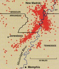
We all think of California as the place for earthquakes, but this area in the lower Midwest has had worse in the past. This map from the USGS locates historic quakes and defines the New Madrid Seismic Zone.
 I was reminded of this when I read this article in Archaeology magazine (sorry but it's the abstract, not the full article) that tells how Missouri archaeologists are cooperating with geologists to use evidence of earthquakes in archaeological stratigraphy to date prehistoric earthquakes. I really liked this picture from the article showing one of the "sand volcanoes" cutting through an archaeological profile and scanned it for you.
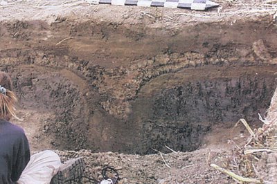 These methods have helped geologists to write a seismic history of the area, showing that the New Madrid Fault has had major earthquake events about every 500 years. People living there now aren't particularly well-prepared if the next one comes soon.
2 comments:
Small quake here betweeen Baton Rouge and New Orleans earlier this week. Radio man says it was 2-point-something on the scale. How 'bout that? Two hurricanes and an earthquake in one season! What do we win???
Wait, I know: FEMA trailers
Matt
Look here at this USGS site and you can see your earthquake
http://earthquake.usgs.gov/recenteqsUS/Maps/US10/27.37.-95.-85.html
Driving betweem Jonesboro and Memphis on both my October and November trips I saw huge convoys of FEMA trailers headed south on I-55, presumably from manufacturers in the Midwest.
Post a Comment